Okanagan Basin Water Board

How drought has shaped the Okanagan

A low lake has meant many things.

A sourced history of the valley's significant droughts, and what each one meant for local infrastructure, everyday life, and the flows that fish depend on. The years marked Analog to today are the ones whose lake level matches where the Okanagan sits right now.

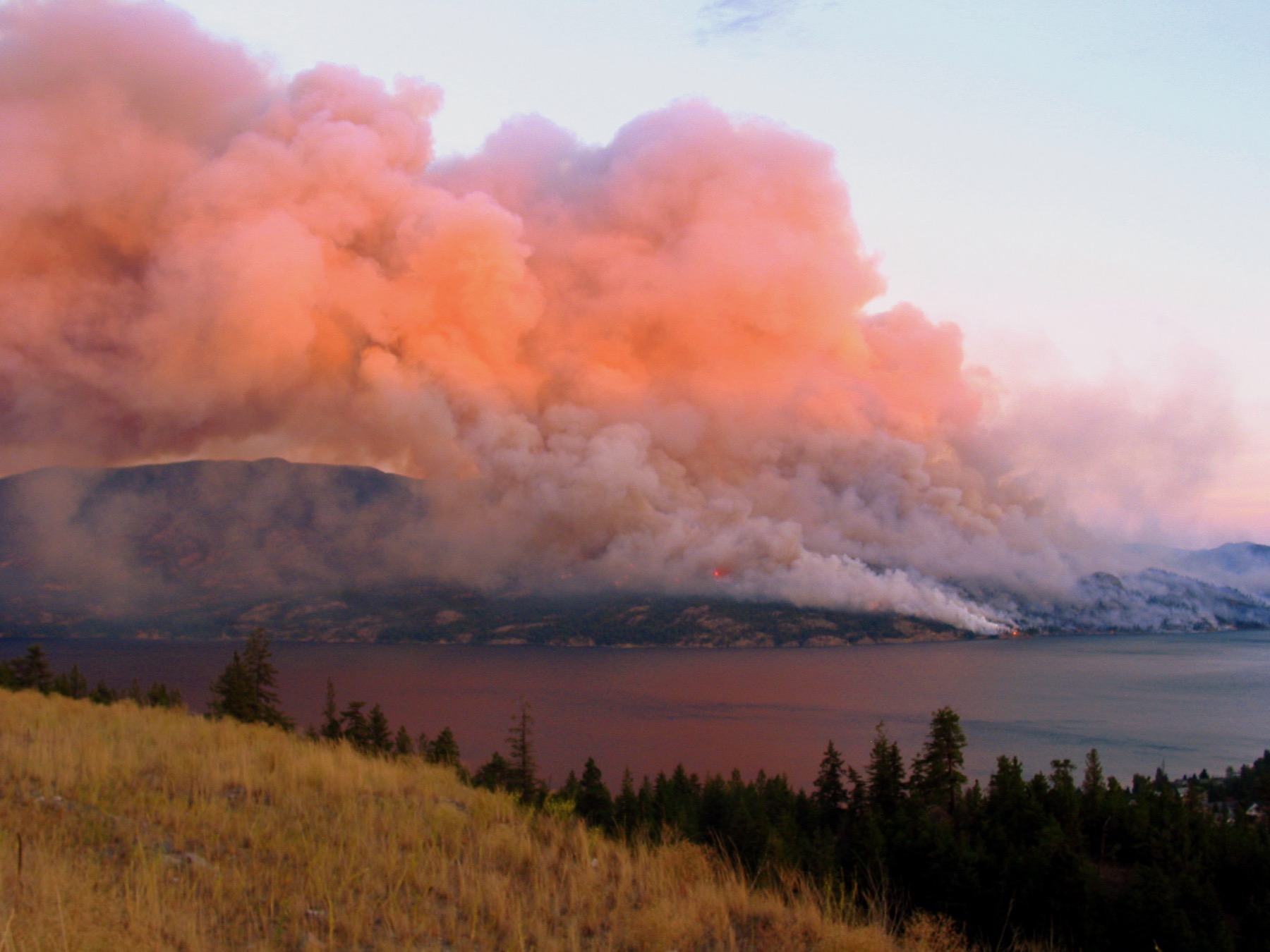
2003 Okanagan Mountain Park firestorm over Okanagan Lake · Photo: Shawn (CDN Aviator), CC BY-SA 2.0

Where we are now · 29 October 2026

2026: the drought this history points toward

Level 3 drought, severely dry on B.C.'s six-level scale as of 22 October 2026. The basin reached Level 5, the highest, on 28 May 2026, the only region in B.C. rated that high. Fourth consecutive year of drought (since 2022).

Level 3 Provincial drought level, 22 Oct 2026 (Level 5 reached 28 May 2026)
58% April 1 snowpack, lowest since records began in 1980
341.34 m Okanagan Lake, 29 Oct 2026 (full pool 342.48 m)
18 of 19 Reporting stream gauges below 75% of normal, week of 22 to 28 Oct 2026
24 of 28 Reporting observation wells below their median for the date, 28 Oct 2026

Winter 2025-26 snowpack fell steadily and set records: 90% of normal on 1 January, 67% by 1 February, all-time record lows at four long-term stations by 1 March, then 58% on 1 April (the lowest Okanagan April-1 snowpack since records began in 1980, beating the 1981 low of 67%), 31% by 1 May, and 16% by mid-May.

Calendar-year precipitation to 29 October 2026 is 55% of the 1991-2020 normal in Vernon, 47% in Kelowna and 40% in Penticton; by 25 May it had been 56%, 47% and 21% of expected. Earlier in the year Okanagan Lake outflows were held near 5 m3/s to conserve storage, and Osoyoos Lake sat at record lows with a cross-border drought declared 12 May.

On snowpack, 2026 is the driest year in the modern record: below the previous low of 1981, and drier than the analog drought years this history is built on. It is the current peak of a multi-year drought that also produced the Level-5 conditions of 2023.

The outlook: winter 2026-27

A strong-to-very-strong ('super') El Nino is forecast for winter 2026-27

NOAA's Climate Prediction Center issued an El Nino Advisory on 11 June 2026: El Nino conditions are present and expected to strengthen into winter 2026-27, with a ~96-99% chance of persisting through December-February and a 63% chance of a very strong event ranking among the largest since 1950. The IRI (22 June 2026) concurs, putting the Nino 3.4 index at +1.7 C and La Nina odds at 0%.

This matters because El Nino winters typically bring warmer, drier conditions and below-normal snowpack to southern B.C. and the Interior. The outlook therefore points to the multi-year Okanagan drought continuing, or deepening, into 2027 rather than easing. On a record-low snowpack, a dry El Nino winter would leave the valley entering 2027 with little stored water to recover on.

Sources

The valley's droughts

The Okanagan's significant drought years

Each year below is documented from primary and government sources, read through three lenses: local government and infrastructure, quality of life, and environmental flow for fish. 4 of them also match today's low lake level on this calendar date.

Okanagan droughts, 1929 to 2026. Colour shows severity; the cluster on the right is the modern acceleration. Hover any marker for detail.
1930 1950 1970 1990 2010 2026 1930 — Extreme (drought of record) drought: The Okanagan drought of record 1930 1970 — Mild drought: A routine dry year the new dam absorbed 1970 1992 — Severe drought: A record-low lake, felt mostly by fish 1992 2003 — Severe drought: Drought and the Okanagan Mountain Park firestorm 2003 2009 — Severe drought: Sixth-lowest inflow since 1921 2009 2015 — Severe drought: Drought becomes British Columbia's top story (Level 4 (max at the time)) 2015 2021 — Severe drought: Heat dome, Level 4, and a kokanee die-off (Level 4) 2021 2023 — Severe drought: Level 5 and the McDougall Creek fire (Level 5) 2023 2026 — Severe drought: Level 5, record-low snowpack, and a strong El Nino ahead (Level 5) 2026 NOW
MildSevereExtreme (drought of record) Also matches today's lake level

Year by year

The drought record, in detail

Filter by severity, or follow the whole thread. Each entry separates what is documented from what is simply absent from the record.

1930

1970

Mild drought Analog to today

1970: A routine dry year the new dam absorbed

Named as a single-year drought in the Canada-BC Okanagan Basin Study, but one the recently completed Okanagan Lake dam handled routinely through carry-over storage. Little social or economic impact is recorded.

1970 is the mildest drought here, and its value is documentary: it is the reference ‘dry year’ in the basin’s founding water-quantity study, and it shows the new regulation system doing its job.

Local government & infrastructure

  • Total basin water requirements to satisfy all uses on Okanagan River (including salmon minimum flows) were estimated at ~244,000 acre-feet/yr under 1970 development; this defines the drought-year supply threshold. This inflow is equalled or exceeded in about three years in four, so lower-inflow years such as 1970 draw on carry-over storage rather than triggering curtailment. [High] (source)
  • The Study’s cost estimates for drought infrastructure impacts (e.g. ~$112,000 to modify Kelowna bridge and ~$100,000 to lower irrigation/domestic intakes) are tied to a hypothetical extreme drawdown to 1116 ft, NOT to conditions actually experienced in 1970; lake levels below 1119.0 ft had never occurred at the time of writing. [High] (source)

Environmental flow & fish

  • Through 1970, minimum in-channel and fishery flows were ‘normally met’: since completion of the Okanagan Lake Dam in 1956, releases met consumptive use and in-channel minimums, and in most years additional discharges were released to provide minimum fishery flows for sockeye salmon migration through Osoyoos Lake and up to Vaseux Lake Dam. A single-year drought like 1970 did not compromise this. [High] (source)
  • The Study documents that flows falling to zero downstream, with fishery requirements unmet, occurred during the severe 1929-31 drought - NOT in 1970. This is the distinguishing severe-case reference, and should not be attributed to 1970. [High] (source)
  • Osoyoos/Okanagan sockeye escapement was highly variable through this era (pre-1999 estimates ranged from ~1,382 in 1961 to ~113,323 in 1967); a specific verified 1970 escapement figure was not retrieved and is not asserted here. Escapement records back to 1961 exist in DFO sources but the 1970 value was not confirmed. [Low] (source)
~244,000 acre-ft/yr Basin water requirement (1970 ref)
normally met Fishery minimum flows

Sources: obwb.ca · pmc.ncbi.nlm.nih.gov · obwb.ca · wateroffice.ec.gc.ca · dfo-mpo.gc.ca

1992

2003

2009

2015

2021

2023

The longer record

What tree rings and lake mud remember

The instrumental gauge record begins only around 1919-1944, far too short to bound how bad Okanagan drought can get. Tree rings and lake-bottom sediments extend the record by centuries to millennia, and they show the modern era has been relatively kind.

Tree rings: the 1930s were one of a family

Ring widths from old Douglas-fir and ponderosa pine at dry interior sites let researchers reconstruct precipitation back into the 1600s-1700s. Watson & Luckman (2004) find recurring multi-year droughts across the southern Canadian Cordillera at 1717-1732, 1839-1859, 1917-1941 and 1968-1979. The famous "dirty thirties" drought was not unique or worst-case; 18th- and 19th-century droughts were as long or longer. Streamflow reconstructions for the neighbouring Fraser and South Saskatchewan basins reach the same conclusion: the gauge era understates the worst droughts.

These annually-resolved records are regional (southern interior BC), not strictly the Okanagan basin.

Sources

Lake sediments: the valley has been far drier

The south Okanagan holds a rarer, deeper archive. Sediment cores from Mahoney Lake, a saline closed-basin lake near Okanagan Falls, record Holocene lake-depth swings of more than 12 metres driven by sustained changes in effective precipitation, and diatom- and midge-inferred salinity shows a mid-Holocene arid interval far saltier, and drier, than today. A core from nearby Kilpoola Lake records the same warm, dry, fire-prone period. These are genuinely Okanagan-basin records of a climate state well outside the modern range.

These local records resolve millennia and centuries, not individual years, so they show much drier states existed rather than dating single multi-year droughts.

Sources

One caution: the Medieval "megadrought" story from the US Southwest does not transfer here. The Pacific Northwest, including interior BC, tended toward wetter winters during that period, so we do not claim a medieval Okanagan megadrought. And no annually-resolved tree-ring streamflow reconstruction exists for the Okanagan River itself; the regional networks are the closest available.

Across the border

The Okanagan is a transboundary drought system

Okanagan Lake drains south through the Okanagan River to Osoyoos Lake on the international border, then into the Okanogan River and the Columbia in Washington. In drought, the two sides are explicitly coupled: the 2013 International Joint Commission Order that governs Osoyoos Lake levels at Zosel Dam raises the allowable maximum from 912 ft to 912.5 ft in officially declared drought years, and the drought declaration itself depends in part on Okanagan Lake inflow falling below about 195,000 acre-feet. A 1993 BC-Washington drought-year accord, under which BC supplies water from Okanagan Lake on request, was later folded into that Order.

The fish layer runs in parallel: the Fish Water Management Tool, used by the Okanagan Nation Alliance, the Colville Confederated Tribes and Fisheries and Oceans Canada, schedules Penticton Dam releases to protect sockeye eggs and smolts through low-water years.

Governance context on file: the 1995 BC-Washington Columbia River MOU and the BC Environmental Assessment Office - Washington MOU (which names Okanogan County).

References & transparency

Sources, citation, and how this was made

How this was built

Each drought year was researched independently against government, hydrological, fisheries, paleoclimate and news sources, then cross-checked. Every factual claim links inline to the primary or government source it rests on, with a confidence tag. The record separates what is documented from what is simply absent (searched, with nothing on record) rather than filling gaps. The pre-1980 years are sparse because digitized Okanagan newspapers end in 1921; those years rest on hydrological reviews and climate data.

Use of AI (transparency statement)

This site was researched and assembled with substantial assistance from AI language models, used to search public sources, synthesize findings, and draft text. To meet communication and accuracy standards, the work was governed by strict rules: every factual claim had to trace to a real, retrievable primary or government source; claims that could not be verified were removed, not published. Findings were produced by multiple independent research passes and reconciled; two separate AI syntheses were also checked against the sourced record, and where they conflicted with the sources, the sources governed (several confident but unsourced AI claims were rejected on that basis). AI does not select what is true here; the cited sources do. Editorial responsibility for the content rests with the Okanagan Basin Water Board.

How to reference this page

Okanagan Basin Water Board (2026). Okanagan Drought History. Retrieved from https://ok-drought-history.vercel.app

For a specific year or figure, cite the linked primary source directly (each claim carries its own source link). Underlying research data and source manifests are kept in the project repository.

Key sources

This is an educational history. Figures are drawn from published sources that may be provisional or subject to revision, and are presented without warranty of any kind, express or implied. It is not intended for emergency, operational, or safety-of-life use. Current-conditions and seasonal-outlook statements reflect sources available at the time of writing and will change.

We acknowledge that the Okanagan (Okanagan) Basin is the unceded territory of the syilx / Okanagan Nation.